Road Trips
Icefields Parkway: Road Trip from Banff to Jasper
The 232 km Icefields Parkway from Lake Louise to Jasper: stops in order with km markers, Columbia Icefield and Skywalk, fuel, winter rules and cell service.
The Icefields Parkway (Highway 93 North) runs 232 kilometres from Lake Louise to Jasper. It follows the Continental Divide through Banff and Jasper National Parks, past more than a hundred glaciers, turquoise lakes and waterfalls. There are no towns along the way, only a few lodges, hostels and one seasonal gas station. Without stops the drive takes three to five hours. Plan a full day so you have time for the viewpoints and short walks.
This guide lists the main stops in order from south to north, with approximate kilometre markers measured from the junction with the Trans-Canada Highway at Lake Louise. Prices in Canadian dollars (CAD), as of October 2026.
Before You Go
- Park pass: The whole parkway lies inside Banff and Jasper National Parks. You need a valid Parks Canada pass to stop anywhere along it. A day pass costs 12.25 CAD per adult or 24.50 CAD for a family or group in one vehicle. Youth 17 and under are free. One pass covers both parks.
- Fuel: The only gas station is at Saskatchewan River Crossing, about 77 kilometres north of Lake Louise. It is open seasonally, usually from April to October. Fill your tank in Lake Louise or Jasper.
- Cell service: There is no cell coverage between the two ends of the parkway. Download your park pass, maps and any tickets before you leave.
- Food: Restaurants are open in summer at Saskatchewan River Crossing, at the Columbia Icefield and at a few lodges. Bring water and snacks.
- Distances: Banff to Lake Louise is 58 kilometres on the Trans-Canada Highway, so Banff to Jasper is about 290 kilometres in total.
If you start in Banff, our Banff National Park guide covers Lake Louise and Moraine Lake. At the north end, the Jasper National Park guide explains what is open after the 2024 wildfire.
Stops from Lake Louise to Jasper
Herbert Lake (km 3)
A small, calm lake just after the start of the parkway. Early in the morning the Bow Range and Mount Temple reflect in the water. It’s a good first stop if you set off at sunrise.
Hector Lake Viewpoint (km 17)
A pullout above Hector Lake, with Mount Hector and the Waputik Range behind it. You only see the lake from a distance here, so a few minutes are enough.
Crowfoot Glacier (km 33)
The glacier on the cliffs of Crowfoot Mountain once had three “toes” spread out like a crow’s foot. One has melted away completely, and the others have shrunk. The viewpoint is on the west side of the road.
Bow Lake (km 36)
Bow Lake is the source of the Bow River, which flows through Banff and Calgary. You can walk along the shore from the parking area. The red-roofed Num-Ti-Jah Lodge stands at the north end of the lake. A trail from the lodge follows the lake to Bow Glacier Falls.
Peyto Lake and Bow Summit (km 40)
Bow Summit, at 2,088 metres, is the highest point on the parkway. From the parking lot a short, steep paved path leads to the viewpoint above Peyto Lake. The lake’s milky blue colour comes from fine rock flour that meltwater carries into it. This is one of the busiest stops on the road, so arrive early or late in the day.
Waterfowl Lakes (km 57)
Two lakes in the Mistaya Valley, below the sharp peak of Mount Chephren. Moose sometimes feed in the shallow water. There is a campground here in summer.
Mistaya Canyon (km 72)
A short trail of about half a kilometre leads downhill from the parking lot to a narrow slot canyon. The Mistaya River has carved round potholes and curved walls into the limestone. A bridge crosses the canyon. The walk back up is the only climb.
Saskatchewan River Crossing (km 77)
Here the Mistaya, Howse and North Saskatchewan Rivers meet. The Crossing Resort has the only gas station on the parkway, along with a restaurant, a cafeteria, a shop and rooms. It is open seasonally, so check before you rely on it outside summer.
Weeping Wall (km 105)
On the cliffs of Cirrus Mountain, several waterfalls drop more than 100 metres beside the road. They are strongest in early summer. In winter they freeze and attract ice climbers.
Big Hill and Big Bend (km 113)
The road climbs out of the North Saskatchewan Valley in a tight hairpin turn. From the pullout at the top you look down the valley you just drove through. Park completely off the road.
Parker Ridge (km 118)
The trail climbs about 250 metres in switchbacks to a ridge above the Saskatchewan Glacier, the longest outflow of the Columbia Icefield. Allow about two hours return. Parks Canada keeps the trail closed from late spring into early summer while it is wet and fragile. Stay on the trail; the alpine plants here grow slowly.
Sunwapta Pass (km 122)
The pass marks the boundary between Banff and Jasper National Parks. From here the road descends towards the Columbia Icefield.
Columbia Icefield and Athabasca Glacier (km 127)
The Athabasca Glacier is one of the most visited glaciers in North America because it ends so close to the road. It is one of six main tongues of the Columbia Icefield, the largest icefield in the Rocky Mountains. Meltwater from the icefield flows to three oceans: the Pacific, the Atlantic and the Arctic.
Toe of the Glacier trail
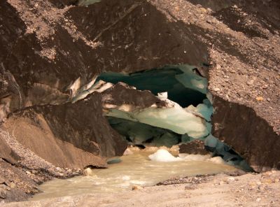
You don’t need a ticket to see the glacier up close. A narrow side road leads to the Toe of the Glacier parking lot, just below the end moraine. From there a short trail with information signs climbs over the moraine to a viewpoint near the ice. Along the way, markers with years on them show where the glacier ended at different times. About a century ago the ice filled the whole valley floor. The glacier has retreated more than 1.5 kilometres since the late 1800s, and you see the loss clearly here.
Do not walk onto the glacier on your own. The ice is full of crevasses hidden under snow, and people have fallen into them. Stay behind the barriers.
Columbia Icefield Adventure
Across the road is the Columbia Icefield Glacier Discovery Centre, run by Pursuit. It has exhibits, restaurants and the Glacier View Lodge. The Columbia Icefield Adventure starts and ends here. A bus takes you to an Ice Explorer, a large all-terrain vehicle that drives onto the Athabasca Glacier, where you can walk on a marked area of the ice. A shuttle then takes you to the Columbia Icefield Skywalk. The whole tour takes about 2.5 to 3 hours.
In 2026 the Adventure runs from May 1 to October 12, depending on weather. Pursuit uses date-based pricing, so check the price for your day on banffjaspercollection.com (opens in a new tab). Children 5 and under ride free, Alberta residents save up to 20 percent, and tickets are 20 percent cheaper for tours after 3:30 pm. The guided Ice Odyssey walk on the glacier is closed for the rest of the 2026 season.
Columbia Icefield Skywalk
The Skywalk opened on May 1, 2014. A walkway of about one kilometre follows the cliff edge to a curved platform with a glass floor, about 280 metres above the Sunwapta Valley. Signs along the way explain the glaciers, rock layers and wildlife of the area. The design won the Future Projects award at the World Architecture Festival in 2011. The Skywalk is included in the Columbia Icefield Adventure and in some Pursuit packages. You reach it by shuttle from the Discovery Centre.
Columbia Icefield to Jasper
Tangle Creek Falls
A few kilometres north of the Skywalk, Tangle Creek drops over a series of rock steps right next to the road. Park on the east side and cross the highway with care. Bighorn sheep and mountain goats often stand along this stretch.
Sunwapta Falls (km 175)
The Sunwapta River drops about 18 metres into a narrow canyon around a small island. A bridge crosses the river above the falls. The flow is strongest in late spring and early summer. A short trail leads downstream to the lower falls.
Athabasca Falls (km 200)
About 30 kilometres south of Jasper, the Athabasca River squeezes through a narrow gap in hard quartzite. The falls are not very high, but the volume of water is large. Paved paths and platforms lead around the gorge and down to the old riverbed below. Stay behind the railings; the rock is slippery.
Jasper (km 232)
The parkway ends at Highway 16, just south of the town of Jasper. Fuel, food and hotels are available here again.
Winter on the Icefields Parkway
The parkway stays open all year, but winter driving here is serious:
- From November 1 to April 1, winter tires (marked M+S or with the mountain snowflake symbol) or chains are required.
- In winter there are no services along the way. The gas station at Saskatchewan River Crossing is closed, and most hotels and restaurants are closed. Hostels are open by reservation only.
- Cell service is available only at each end of the road.
- Crews clear the road between 7 am and 3:30 pm. Drive in daylight.
- The road is not salted, so packed snow and ice can last for days.
- The road can close because of storms or avalanche control. Check 511 Alberta (opens in a new tab) before you set off.
Carry a winter safety kit with water, food, warm clothes and blankets, start with a full tank and extra windshield washer fluid, and tell someone your route and expected arrival time. Keep to the speed limit, especially in the signed caribou habitat zone, and stay at least 30 metres from wildlife.
Frequently asked questions
How long is the Icefields Parkway?
The Icefields Parkway is 232 kilometres long, from the Trans-Canada Highway at Lake Louise to Highway 16 at Jasper. From Banff town it is about 290 kilometres to Jasper.
Where can I get gas on the Icefields Parkway?
Only at Saskatchewan River Crossing, about 77 kilometres north of Lake Louise, and only in season, usually from April to October. In winter there is no fuel at all between Lake Louise and Jasper.
Do I need a park pass to drive the Icefields Parkway?
Yes, if you stop anywhere along the road. The parkway is inside Banff and Jasper National Parks, and one Parks Canada pass covers both.
Is there cell service on the Icefields Parkway?
No. You have coverage only near Lake Louise and Jasper. Download maps, tickets and your park pass before you leave.
Can I drive the Icefields Parkway in winter?
Yes, but winter tires or chains are required from November 1 to April 1, there are no services, and the road can close in bad weather. Check 511 Alberta and travel in daylight.
Comments
No comments yet. Questions about this article are welcome.
Thank you. Your comment will appear once we have checked it.